Sunday, April 16, 2006
To the waters edge
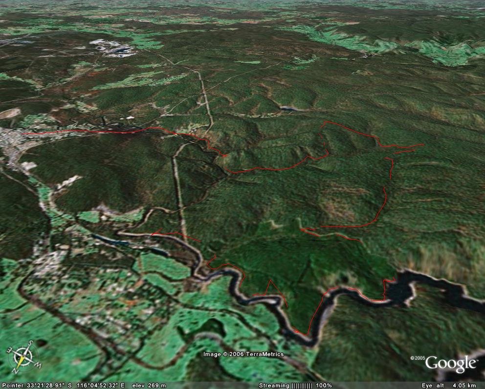
Had a great ride with Damon. He parked his car at the information bay at Wellington Dam turnoff and I gave him a lift back to my house with the idea that we'd ride out to his car and then he'd give me a lift home. After picking him up we went to my place and had a look at maps and Google Earth and in the end decided that the route over the top of the dam wouldn't be great and we'd go for option B. This route starts south of Collie, cuts across the bottom of a farm and then goes over some gravel rolling track to Palmer road, which you follow for about a kilometre before turning left up a track which has a sign that says APIARY but doesn't actually appear on any maps. It's a nice leafy unused track that inclines gradually upwards for ages and then towards the end increases in steepness yet again before leveling out on top of the hill. It's the sort of hill where when you're riding with mates someone is sure to shoot off ahead only to end up blowing up halfway up the hill. It's a long hill and slow and steady is best. Looking on the maps there does appear to be a track that bypasses the steep part of the hill and shortens the route a bit. Anyway after a short decline and another uphill you get to Black Dicks Road where it joins up with Old Mill Road. We stopped here for a breather and a snack and checked our maps. My original intention was to follow Old Mill Road but there was a great track along Randall Road which follows Silver Wattle Gully, so we mounted up again and went north along Black Dicks Road for about a kilometre before turning left onto Randall Rd which was pretty much a continuous gentle downhill for a couple of kilometres. The track was pretty much unused and the Silver Wattle had grown over the track to create a tunnel effect, with branches pulling at the handlebars. At the end of Randall Rd we went left and followed the boundry of the Mungalup pine plantation, after some steep rutted downhill we arrived at the waters edge. The water was wide and far too deep to cross, which was a change from last year when the dam was really low and there was no water at this point at all.
After a bit of a look around we followed the river back towards Collie. We went along Palmer Rd for a few km before we found a place to cross the river. Riding down a steep bank to the river I got caught in a rut and went over the handle bars. it was one of those slow motion things with everything being a blur. I saw the rut and I think if my tyres and suspension had been a bit softer I might have survived, but as it was I didn't. Despite being rocky ground I didn't do any major damage, my shoulder aches a bit but nothing broken or torn. I always worry about breaking a collar bone which seems to be one of the most popular injuries these days. After crossing the river on slippery logs we followed some of the track from the Collie Marathon Relay course before hitting the tarmac for the last 3 km into town. It was getting dark so Damon threw his bike in my car and I drove out to his car and dropped him off. We'll have to investigate the west side of the dam next week. All up we covered 40 km in about three hours. If you have Google earth you can download the route we took from here. The ride Damon is planning will go from Collie to Bunbury and will be a distance of about 100 km, it's planned for around about October 2006.
![]()